
I. Pre-contact Trade on Turtle Island
Pre-contact Trade and Trade Centres
Pre-contact Trade
Exchange amongst individuals and societies is one of the most pervasive and enduring acts in human history and is integral to the evolution of society. Many economists and social philosophers throughout the 20th and 21st century argue that the development of sophisticated systems of exchange play a central role in social and political progress and, in some cases, are necessary for survival (Smith, 1976 [1776]; Marx, 1904 [1857-58]).
While exchange and systems of exchange are pervasive in human societies, the nature of exchange is highly variable in terms of the reasons for the exchange, the goods traded, trade volumes and the social contexts of the exchange systems. There are two broad categories of trade goods, subsistence goods and prestige goods. Subsistence or utilitarian goods are intended to provide the basic needs of a group (Earle, 2010). These mainly include food, technology, tools and raw materials. Some raw materials like obsidian, high quality chert and copper were highly sought after and sometimes travelled thousands of kilometers from where they originated. The more exotic prestige goods also travelled vast distances. Conch and whelk shells from the Gulf of Mexico and shell beads from the Gulf of California have been found throughout the U.S. mainland and as far north as Canada. Some of the more valuable trade goods include lithic materials like obsidian and high quality chert, native copper, galena, marine products and various minerals like red ochre. Their value was due in large part to their scarcity, applications in ceremonial practices, and usefulness as tools, however, the value of these and other commodities changed over time as populations grew and societies and exchange networks evolved (Earle, 2010).
Natural Resources and the Scarcity of Resources
Some highly valued resources like native copper and obsidian were abundant in certain areas and in relatively short supply in most other parts of the continent. It was only through trade that these resources were made broadly available across the continent. The overwhelming majority of native copper found across North America, for example, was sourced from present-day Lake Superior. This is the largest known native copper deposit on the planet and could be mined relatively easily. Copper was largely regarded as a prestige good and used for ceremonial purposes and to adorn traditional clothing and regalia. It could, however, also be fashioned into tools such as knives, axe heads and fish hooks, but it’s utility value was diminished by its scarcity and durability relative to other raw materials that were more abundant and could be crafted more easily. Obsidian is another example of a scarce and valuable resource. Obsidian has a crypto-crystalline structure which can be fashioned relatively easily into razor-sharp knives or cutting instruments through a process called knapping. It is formed through the rapid cooling of viscous lava and only found in areas of the continent where there were volcanoes. Since volcanoes are only found on the west coast and throughout Central America, many of the north-eastern societies relied on high quality cherts and other lithic materials. The mountain ranges and onerous terrain that divided the east and west acted as a natural barrier for the trade of this precious resource.
Long-distance Exchange Networks
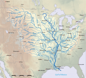
Trade between nations was largely dictated by the availability of scarce and valuable raw materials in territories and the natural landscape. Mountain ranges and onerous terrain, for example, acted as natural barriers for trade, while oceans lakes and waterways allowed for vast quantities of trade goods to be transported relatively easily. Trade between nations and across vast distances was made possible through the network of rivers and durable lightweight canoes.
Long-distance exchange networks in pre-contact North America were facilitated through two types of systems: down-the-line exchange systems and direct exchange systems. Down-the-line exchange systems are most common in smaller societies and involve a series of relatively small exchange networks. Trade goods would travel vast distances through a series of smaller networks. Neighbouring societies and communities would trade amongst each other and the trade goods would reach their final destinations after passing through a relatively large number of intermediaries (Renfrew, 1975, 1977). Direct exchange systems, on the other hand, involved far fewer intermediaries and were common in more complex societies. These systems often involved specialised traders and emissaries who would transport goods, knowledge, customs and beliefs across vast distances in order to strengthen alliances with distant societies. The goods traded through these systems were typically smaller quantities of prestige goods that were highly valued by social elites (Sanger et al. 2019).
Trade Centres
The major trade centres in pre-contact North America are well known, but not often taught in schools. While a detailed account of all of these societies is out of scope for an introductory module of this nature, we plan to further develop this resource over time and provide a more comprehensive overview of the rise and fall of trading empires through time. The following sections are intended to provide a glimpse into a few of the most influential exchange societies.
Since the arrival of European settlers in North America there have been countless studies seeking to better understand the complex social and exchange networks that existed in prehistoric North America. Some of the largest trade centres were strategically located along vast river networks or along the shores of lakes and oceans. Not only did this provide an abundant source of food and raw materials, but also helped facilitate the transportation of goods, ideas and people.
By 1450 A.D., there were numerous established trade centres and exchange networks connecting the far reaches of the continent. Mother-of-pearl from the Gulf of Mexico has been found in Manitoba, and copper from Lake Superior as far south as present-day Louisiana (Mann, 2006). Important areas in the study of pre-contact exchange include the Saint Lawrence Valley (Lothrop 1989; Snow 1980; Wright, 1994), the middle Atlantic region (Stewart, 1994), the Maritime Provinces, the Midwest, and the Lytton-Lillooet and Dalles-Deschutes localities in present-day British Columbia (Morin, 2015; Galm,1994).
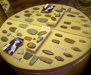
These and numerous other sites and cultures provide a window into prehistoric exchange across North America. A variety of geochemical instruments and techniques allow archaeologists to identify source materials of artifacts recovered from archeological sites. Based on where these artifacts were found and their points of origin we can start to piece together these elaborate and sophisticated systems of distribution and redistribution centres across the continent and into present-day South America. We will discuss two of the most important trade centres, Poverty Point and Spiro – both of which are located along or near the Mississippi.
The Spiro Mounds
The Spiro Mounds are located in present day eastern Oklahoma south of the Arkansas River. The 80-acre site is known to many archeologists worldwide for the vast array of artifacts that have been uncovered since the early 18th century. Historically, however, this was home to a powerful and sophisticated culture of Spiroan people who inhabited the northern part of the Caddoan Mississippian region from about 900-1450 AD. The Spiro are regarded by some as once the single most powerful group to ever exist in North America (Brandes, 2021). It was not the largest city by geography or population, but it was a hub for trade (Schambach, 2000), an important ceremonial centre and it played a significant role in the development of prehistoric societies (Sievert et al. 2011).
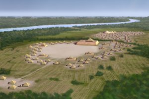
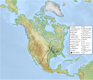
They are perhaps best known for their mounds and major earthworks, but their proximity to several river networks including the Mississippi River, the Arkansas River and the Canadian River provided the Spiro people access to a vast portion of North America. Their trade networks extended from the Atlantic to the Pacific Ocean, as far south as central Mexico and as far north as Canada.
Excavation of the Spiro mounds in eastern Oklahoma revealed several artifacts originating from various regions across North America. Among the artifacts found were obsidian from the Valley of Mexico, copper from the Great Lakes, engraved lightning whelks from the Florida Keys, and over 20,000 shell beads originating from the Gulf of California, the Gulf of Mexico and along the Atlantic coast (Sievert et al. 2011; Study of Antiquity, 2021; Brown 1996; Kozuch 1998). Importantly, some of the beads found in the Spiro site were made from Gulf of California dwarf olive shells or Olivella dama. While there is no evidence of strong cultural ties to the west, the discovery of these beads supports trade between Puebloan and Plains peoples during Late Prehistoric times at about A.D. 1400 (Kozuch, 2002).
One of the greatest collections of Spiro Mound artifacts was on display from February – May, 2021 at the National Cowboy and Western Heritage Museum in Oklahoma City, Oklahoma. They displayed over 1000 pearls; 63 matched sets of copper ear flares from the Great Lakes; 30 copper axes; 1 gallon of pearl beads; 800 shell beads; cane basket with 30 face masks; various pipes; blankets; 100 shell beads; bifaces; arrow points; 7 maces; 10 cane bundles; bottles; and a stack of 3 blankets. In a YouTube video titled “The Kingdom of Spiro: A Forgotten Civilization,” Dr. Eric Singleton of Spiro, Curator of ‘The Art of the Mississippian World’, explains that the Mississippian cultures were highly developed who flourished between 800 to 1600 CE and established great cities in areas such Cahokia in present day Illinois, Georgia, Kincaid, Alabama; and Oklahoma (Study of Antiquity, 2021).
What happened to this once great and powerful city?
The Spiro region was a gathering place for over 550 years where peoples from nations and communities across North America traded all varieties of products. It is believed that the unpredictable climate eventually forced inhabitants to abandon the region in the early 1400s and the Spiro people are thought to have migrated south to join other Caddo-speaking nations and west towards villages around the Washita River in present-day western Oklahoma. There is an ongoing debate about who the descendants of the Spiro people are though it is believed that the descendants of those who built Spiro mounds are likely either the Wichita bands (Wyckoff, 2008), the Caddo Nation and/or the Tunica people in the Mississippi River Valley (La Vere, 2007).
Exotic materials and artifacts found at the Spiro site:
(Sievert et al. 2011; Brown 1996; Phillips & Brown 1978; Barker et al. 2002; Kozuch 1998)
- Mill Creek chert from southwestern Illinois,
- marble, from the southern Appalachians in eastern Tennessee and northwest Georgia,
- greenstone and phyllite from the southern Appalachians (possibly northern Georgia),
- copper from either the Lake Superior region or the southern Appalachians,
- galena from the Potosi formation near Cahokia,
- Arkansas Novaculite from the Ouachita Mountains,
- Boone chert from the Southern Ozarks,
- Red River Jasper from the Red River basin in Texas,
- Alibates Agatized Dolomite from the Texas Panhandle,
- mica from western North Carolina,
- Burlington chert from Missouri,
- Dover chert from either the Cahokia area or Tennessee,
- Kaolin chert from southern Illinois,
- Alibates dolomite from the Texas panhandle,
- Obsidian from Hidalgo, Mexico, near the city of Pachuca,
- Smoky Hill jasper from northern Kansas or southern Nebraska,
- Olivella Nivea beads from the Gulf of Mexico,
- Smithport Plain ceramics from the Arkansas River valley,
- Coles Creek Polished Plain ceramics from southwestern Arkansas,
- Pennington Punctate-Incised ceramics from the Mississippi valley area of southern Arkansas,
- Hiwassee Island Red-on-Buff ceramics from western Tennessee,
- Nashville Negative Painted ceramics from central Tennessee,
- Powell Plain ceramics from the American Bottom,
- Lightning whelks (Busycon sinistrum) from the eastern Gulf of Mexico.
Poverty Point Culture
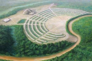
Poverty Point was one of the oldest chiefdoms in North America and thrived during the late archaic period from 1730-1150 BC (Louisiana Division, 2014). The site is located in present-day Ouachita Parish, Louisiana, on a natural ridge along the banks of the Bayou Macon in the lower Mississippi. The site is home to an impressive array of geometric earthworks including six parallel rings that enclose a raised central plaza and several large mounds (Webb, 1968).
At the time, North American groups and societies were largely nomadic hunter gatherers and depended on foraging wild resources. Poverty Point inhabitants were unlike any of their time and are believed to be one of the first societies to practice city planning, agriculture and crop domestication (Ward, 1998; Webb, 1968; Gregory, 1991). In addition to being one of the oldest and largest cities in North America and likely one of the first agricultural societies, there is also evidence that they were expert surveyors, astronomers and innovators.
The bayou and nearby river networks provided an abundance of resources, but one thing that Poverty Point didn’t have is stone and other lithic materials used to make tools. Despite this, there were thousands of stone artifacts recovered from the Poverty Point archeological site. Many of these artifacts are made from materials that were sourced from areas hundreds kilometres away, and in some cases, more than 1,600 kilometres. The breadth and volume of exotic materials found at this site is evidence of a vast exchange network that was in place from about 1500-1100 BC (Gibson, 2010).
Cahokia
Cahokia, located near modern-day St. Louis where the Missouri drains into the Mississippi River. This location provided fertile soil, an abundance of natural resources and was a near-ideal location for the transportation of people and goods. This metropolis once boasted the greatest population centre north of the Rio Grande and is thought to be the point of origin of the entire Mississippian culture (Fosaaen, 2022). This culture was best known for its maize agriculture and it was said that fields of maize once rippled out almost as far as the eye could see (Mann, 2011).
References
Brandes, H. (2021). This little-known Native American society was once as powerful as the Aztecs and Incas. National Geographic. Retrieved from: https://www.nationalgeographic.com/travel/article/spiro-and-the-art-of-the-mississippian-world-in-oklahoma
Brown, D.D. (1996). The Spiro Ceremonial Center: The Archaeology of Arkansas Valley Caddoan Culture in Eastern Oklahoma. 2 vols. Memoirs of the Museum of Anthropology No. 29. University of Michigan, Ann Arbor.
Earle, T. (1994). Positioning Exchange in the Evolution of Human Society. In T. G. Baugh & J. E. Ericson (eds.). Prehistoric exchange systems in North America. New York: Plenum Press.
Fosaaen, N. (2022, January 30). Cahokia Field Trip: The Mississippian Culture’s First City. [Video]. https://www.youtube.com/watch?v=6GsZC_DDiho
Galm J.R. (1994). Prehistoric Trade and Exchange in the Interior Plateau of Northwestern North America. In T. G. Baugh & J. E. Ericson (eds.). Prehistoric exchange systems in North America. New York: Plenum Press.
Gibson, J.L. (1994). Empirical Characterization of Exchange Systems in Lower Mississippi Valley Prehistory. In T. G. Baugh & J. E. Ericson (eds.). Prehistoric exchange systems in North America. New York: Plenum Press.
Gregory, H.F. (1991). Terral Lewis: Recapitulation. In Kathleen M. Byrd (eds.). The Poverty Point Culture: Local Manifestations, Subsistence Practices, and Trade Networks. pp. 121-129. Geoscience and Man 29. Geoscience Publications, Baton Rouge.
Jobin, S. (2013). Cree peoplehood, international trade, and diplomacy. Revue Générale De Droit, 43(2), 599-636. https://doi.org/10.7202/1023207ar
Kozuch, L. (2002). Olivella Beads from Spiro and the Plains. American Antiquity, 67(4), 697-709. doi:10.2307/1593799
La Vere, D. (2007). Looting Spiro Mounds: An American King Tut’s Tomb. Norman: University of Oklahoma Press.
Louisiana Division of Archaeology. (2014). Poverty Point. In Discover Archaeology. Louisiana Department of Culture, Recreation and Tourism. Retrieved from: www.crt.state.la.us/cultural-development/archaeology/discover-archaeology/poverty-point/
Mann, C.C. (2006). 1491: New revelations of the americas before columbus (1st Vintage Books ed.). Vintage Books.
Marx, K., 1857-58 (1904). A Contribution to the Critique of Political Economy: Translated from the Second German Edition by N. I. Stone, Charles H. Kerr, Chicago
Morin, J. (2015). Near-Infrared Spectrometry of Stone Celts in Precontact British Columbia, Canada. American Antiquity, 80(3), 530-547. doi:10.7183/0002-7316.80.3.530
Phillips, P. & Brown, J. A. (1978). Pre-Columbian Shell Engravings from the Craig Mound at Spiro, Oklahoma, Part 1. Cambridge, Mass.: Peabody Museum of Archaeology and Ethnology.
Renfrew, C. (1975). Trade as Action at a Distance: Questions of Integration and Communication. In Jeremy A. Sabloff and C. C. Lamberg-Karlovsky (eds.) Ancient Civilization and Trade. University of New Mexico Press, Albuquerque.
Renfrew, C. (1977). Alternative Models for Exchange and Spatial Distribution. In Timothy K. Earle and Jonathon E. Ericson (eds.) Exchange Systems in Prehistory. Academic Press, New York.
Sanger, M., Padgett, B., Larsen, C., Hill, M., Lattanzi, G., Colaninno, C., Culleton, B.J., Kennett, D.J., Napolitano, M.F., Lacombe, S., Speakman, R.J. & Thomas, D. (2019). Great Lakes Copper and Shared Mortuary Practices on the Atlantic Coast: Implications for Long-Distance Exchange during the Late Archaic. American Antiquity, 84(4), 591-609. doi:10.1017/aaq.2019.59
Schambach, F. F. (2000). Spiroan traders, the sanders site, and the plains interaction sphere: A reply to bruseth, wilson, and perttula. Plains Anthropologist, 45(171), 7-33. https://doi.org/10.1080/2052546.2000.11931986
Sievert, A. K., Rogers, J. D., Urcid, J., & Smithsonian Institution. (2011). Artifacts from the Craig mound at Spiro, Oklahoma. Smithsonian Institution Scholarly Press.
Smith, A., 1776 (1976). The Wealth of Nations. University of Chicago, Chicago.
Stewart, R.M. (1994). Late Archaic through Late Woodland Exchange in the Middle Atlantic Region. In T. G. Baugh & J. E. Ericson (eds). Prehistoric exchange systems in North America. New York: Plenum Press.
Study of Antiquity and the Middle Ages. (2021, May 8). The Kingdom of Spiro: A Forgotten Civilization [Video]. YouTube. https://m.youtube.com/watch?v=UDP9zHbJKN8
Ward, H.D. (1998). The paleoethnobotanical record of the poverty point culture: Implications of past and current research. Southeastern Archaeology, 17(2), 166-174.
Webb, C.H. (1968). The extent and content of poverty point culture. American Antiquity, 33(3), 297-321. https://doi.org/10.2307/278700
Wright, J.V. (1994). The Prehistoric Transportation of Goods in the St. Lawrence River Basin. In T. G. Baugh & J. E. Ericson (eds.) Prehistoric exchange systems in North America. New York: Plenum Press.
Wright, J.V. (1982). La circulation de biens archeologiques dans Ie bassin du Saint-Laurent au cours de la prehistoire. Recherches amerindiennes au Quebec 7(3):193-105.
Wyckoff, D. G. (2008). Intertwined legacies: The Wichita and Dr. Robert E. Bell. Plains Anthropologist, 53(208), 377-380. https://doi.org/10.1179/pan.2008.027

Feedback/Errata