
I. Pre-contact Trade on Turtle Island
Pre-contact Trade Goods
Native Copper
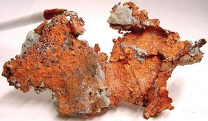
Copper in North America (also known as ‘Native Copper’) is considered to be one of the most popular exchange items in the pre-contact period. Copper from the Great Lakes region, Yukon, Northwest Territories, Arizona, Florida, North Carolina, and more have been identified across Turtle Island by archaeologists and European explorers. Researchers are able to use a “trace elemental composition” technology on major copper deposits, which has the potential to reveal the origin time and location of copper artifacts (Veakis, 1979). However, tracing the element is difficult because of the purity of native copper, researchers recommend a minimum of 10 samples to chemically characterize a source (Cooper & Simonetti, 2021). Native copper has unique and distinguishable characteristics; European explorer, Richard Grenville, described native copper on an expedition to Virginia in 1585, “It was the colour of our copper, but softer” (Rickard, 1934). There are many references to the creation of native copper tools that have been shaped with hammers, a practice that cannot be done with the copper from deposits in Europe (Rickard, 1934). Being able to trace the origins and identify the special malleable qualities of native copper, researchers are able to uncover trade routes that may have existed throughout the prehistoric period.
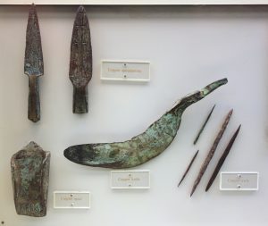
According to chemical sourcing, copper-working at sites around the Great Lakes began as early as 7000 years ago — a period known as the “Old Copper Period” (Sanger et al. 2019). Copper from the Great Lakes region–primarily Lake Superior–has been found in many excavation sites across the northeast. The earliest known copper artifacts identified from this region were generally for utilitarian use (tools, knives, and axes) and were found in present-day New England and Ontario (Fowler, 1973). Great Lake copper was also discovered to have usage in ornamental, ceremonial, and mortuary practices. In New York, Massachusetts, and Rhode Island, Great Lakes copper has been found in the form of ornamental beads, pendants, plates, and bracelets (Anselmi, 2004).
Across the north, copper has been found in Alaska, Yukon, Northwest Territories, and Nunavut. The copper from this region has been primarily associated with two groups; Tlingit in Alaska (Kletsan) & Kugluktuk in the Northwest Territories (Kogloktok/Coppermine River). Archaeological evidence suggests that Kletsan copper has been used for utilitarian purposes “at least 1000 years ago in the western Subarctic and as early as 2000 years ago in the central Canadian Arctic” (Cooper & Simonetti, 2021). The Inuit and Dene used this resource to craft fish hooks, projectile points, awls and various types of knives. The Coppermine River site is considered to be largely inaccessible due to the first ten miles of the river being harsh, even for canoes (Gilbert, 1931). However, using this route, a one-way voyage to Alaska can be made once per year in the summer.
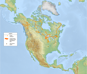
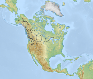
Great Lakes Copper Movement
- Lake Superior Copper Articles found in New England (Fowler, 1973)
- Lake Superior Copper Ornamental found in several sites in New York (Fowler, 1973)
- Lake Superior Copper Ax found in Kingston (Fowler, 1973)
- Lake Superior Copper Beads found in Adena Burials at Brookfield, Massachusetts (Fowler, 1973)
- Lake Superior Copper plates found in Newport (Fowler, 1973)
- Lake Superior Copper ornaments found in use on Huron territory (Fowler, 1973)
- Lake Superior Copper found in Ohio (Anselmi, 2004)
- Lake Superior Copper found in Ontario (Rickard, 1934)
Alaska Copper Movement
- Kletsan copper has been found in southwestern Yukon (Cooper, Simonetti, 2021)
- Kletsan copper has been found in south-central Alaska (Wrangell & St. Elias Mountain Ranges (Cooper & Simonetti, 2021)
- Kletsan copper found in northern Nunavut (Cooper, SImonetti, 2021)
NWT Copper Movement
- Coppermine River Copper found used by Inuit (Gilbert, 1931)
- Coppermine River Copper found used by Dene (History Museum, n.d.)
Obsidian
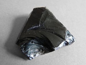
Obsidian is a valuable resource that is challenging to obtain because of its limited source origins. Despite this, obsidian tools have been identified “all over North America” and were traded for thousands of years by various First Nations (Rajnovich, 1994). Notable obsidian sites in this study have originated–but not limited to–from British Columbia, Alaska, Oregon, Wyoming, and Mexico Valley. Researchers are able to trace the material with a technique called non-destructive energy dispersive x-ray fluorescence (XRF) on artifacts that have relocated due to human activity (Carlson, 2010). This technology and archaeological studies help identify evidence of trade routes that may have existed before European contact.
The Yellowstone Area has produced some of the highest quality obsidian, and has been proven to have traveled far distances. Arguably the best known source of volcanic glass [obsidian] in the United States, Yellowstone obsidian has been found across Turtle Island. Notably found in large quantities across California, Oregon, Washington, British Columbia, and up to 2400 kilometers east of the Rocky Mountains in mid-continental Hopewell sites (Schieber & Finley, 2011).

In the Pacific Northwest region, obsidian has been identified to have been active in trade for 10,000 years (Carlson, 2010). A high number of obsidian tools, fishing hooks, and arrowheads were found across British Columbia, Yukon, and Alaska regions, indicating a region-wide exchange network. To support this, researchers have collected additional commodities that provide evidence of long-distance trade, such as shellfish hooks, Kletsan copper ornaments, harpoon heads, soapstone, quartz, and other raw materials (Carlson, 2010). Before the arrival of European explorers, the region of British Columbia was thriving with reciprocal exchange through the movement of distant resources, and is certainly an important example of entrepreneurship.
Approximately 4000 years ago (in the early formative period), obsidian was exchanged heavily in the Mexico region. Obsidian sources in Oaxaca valley were utilized by Indigenous groups for their own use, economic benefits, and relationship building (Feinman, et al., 2018). Researchers in the 21st century are particularly drawn to the study of obsidian because it is one of the best options for uncovering ancient economies in the Mesoamerica civilization. Feinman, et al., (2018) suggests that obsidian is presently the most useful class of artifacts for tracing the evident dynamism of the ancient Mesoamerican economy.
Many Indigenous stories of nation-to-nation exchange are rooted in reciprocity and there are numerous examples of entrepreneurship and wealth accumulation. For instance, obsidian from the lower Columbia River area (Obsidian Cliffs and Newberry Volcano) were often controlled by “powerful elites, representing resource-controlling corporate households and lineages who maintained their position in part by their central role in the wide-ranging economy” (Connolly et al., 2015). Further, there is evidence that these elites had a comprehensive operation with product manufacturing and transportation. Connolly, et al. (2016) suggests there was “commoditized product systematically quarried and shaped into uniform, transportable forms and transferred to distant consumers through a regional exchange network.”
Movement
- Yellowstone Obsidian
- Found 2400km east of Rocky Mountains in mid-continental Hopewell Sites
- Found across the Sierra Nevada (between California and the western Great Basin)
- Found in large amounts across all five regions: Eastern Idaho, Southeast Idaho, Southwest Wyoming, Northwest Wyoming, Southwest Montana
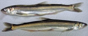
Oolichan Grease
Oolichan Grease (or Eulachon, Hooligan) is an oil that is extracted from the Eulachon fish–a small anadromous species of smelt–that was frequently traded among many Indigenous peoples between California, Oregon, Washington, British Columbia, and Alaska. The oil had a variety of uses; including for consumption and medicinal purposes. According to Moody (2008), “Eulachon Grease was also used as a medicine if a poisoning was suspected, as a laxative, as a cure for dry skin and was given to anyone who was sick” (p. 82). The oil is also referred to as the “golden grease” because it stimulated a vast exchange network, resulting in a series of economic benefits for every nation involved (Hirch, 2003, p. 4). The extensive relationships began from the frequent trade of the oil, and is known as the Grease Trails, “this trail system was the lifeblood of the native culture and economy” (Moody, 2008, p. 81).
The result of this diverse trading network meant that many First Nations groups had to collaborate on a common language as a communication of exchange. The varied nations and Europeans (when they became involved post-contact) adopted a version of the Chinook language (referred to as the ‘Chinook Jargon’) as the common trading language (Eells, 1894). However, the language has many influences because of the diverse peoples involved, including the Nootka, Nisqually, Chinook, Chihailish, and others. Eells (1894) explains, “No one person is competent to write a dictionary of the Chinook jargon, because it is so constantly changing and is used very differently at the same time in different localities” (p. 300). This is an excellent example of collaboration that has been initiated by Indigenous peoples from the pre-contact era.
In addition to the trade of Oolichan Grease, these trails became an exchange network based on reciprocity, with the amount of trade “being a sign of sociocultural complexity of a given society” (Carlson, 2010, p. 308). Further, exchange in these communities would be practiced as giving, receiving, and repaying–only sometimes involving profit. Many items were exchanged, such as blankets, pemmican, bitterroot, dried berries, dried meat, leather, and clothing (Hirch, 2003). In addition, these nations shared valuable information on new technologies, such as basket weaving, canoe making, and plant knowledge (Dressay, et al., 2010). This short description only captures a fraction of the thousands of years of sophistication and economic development that Indigenous peoples created in these trails, before it would ultimately be renamed after the European explorer, Alexander MacKenzie.
Marine Shells
Marine shell (or seashells) is the outer protective layer created by an animal that inhabits the upper tidal zone easily obtained at low tide in sandy and rocky areas of the shoreline. They are found is almost all bodies of water, but the most prized shells were sourced from along the East, West and Gulf Coasts, Puget Sound and Vancouver Island. Harvesting marine shell was not always easy and sometimes involved dredging from a canoe with long, fine-toothed rakes (Galm, 1994).
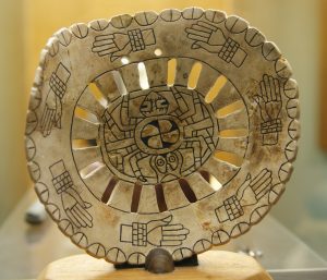
The chronology of marine shell found in archeology sites across North America indicates that marine shell has been traded on this land for at least 10,000 years (Galm, 1994). They were used in fashion, for decoration and ceremonial purposes and, at one point, were even used as a standard form of currency for trade (Baugh & Ericson, 1994). They were often engraved and considered to be a symbol of prestige. They were used for rattles and pendants as well as to make beads, labrets, gorgets, and other shell ornaments for wealth, status, and authority (Carlson, 1994). They also had great utilitarian value. Marine shells found in interior sites were widely fashioned into tools like knives, scrappers, adze blades and harpoon-arming tips (Galm, 1994). Artifacts containing shell debris recovered from archaeological sites indicate that sandstone saws were used to cut marine shell, and chert microdrills and blades were used to manufacture shell beads (Galm, 1994).
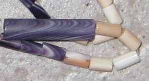
Prior to European contact, the New England coastal tribes used white and purple clam and other shells only found in the northeastern seaboard to manufacture wampum belts that were–and still are–used to maintain political associations for trade and diplomacy (Baugh & Ericson, 1994a). Wampum Belts were principal documents which contained history like a national archive that had encrypted codified laws that allowed narrative used to regulate and maintain relations and regions between Indigenous nations that was common knowledge around the Great Lakes and St Lawrence River regions, and east of the Mississippi (Hamilton, 2018; Lytwyn, 1997; Morito, 2012).
Marine shells were one of the most widely traded items across the continent and trade networks are visible through spatial analyses of marine shell artifacts. Shells of all types can be found in the Plateau, Great Plains, the Midwest, Mississippi River regions, Mississippi Rivers, Fraser and Columbia River systems, Great Lakes, Great Basin, and in eastern North Dakota adjacent to parts of Minnesota, Manitoba, and Saskatchewan (Baugh & Ericson, 1994a). These trade relationships are well documented at the time of Euro-American contact. For instance, archaeologists suggest the Olivella shell bead trade intensified between the Plains and Pueblo peoples between 1350-1600 AD (Clark et al., 2013).
Red Ochre
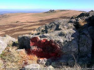
Red Ochre is a mixture of ferric oxide, clay and sand mined directly from the earth in natural deposits found throughout Newfoundland, Labrador, California, Oregon, Wyoming, Alaska, Wisconsin, Michigan, Illinois, Iowa, and Ohio (Descantes, Erlandson & Robertson, 1999; Barret & Jarvis, 2019; Quimby & Ritzenthaler, 1962). This naturally occurring pigment was a popular trade good and widely used amongst the Indigenous peoples of the Americas. It was often traded in its natural powdered form and used either for ceremonial purposes or mixed with fish oil to create paint (Barret & Jarvis, 2019). In some cases, red ochre was traded in an already processed form. The Kootenay Peoples from southeastern British Columbia, northern Idaho, and western Montana were known for trading in red oxide, which they processed from red ochre pigment mined in the Banff National Park region (Jobin, 2013, p.614).
Traditionally, red ochre was used for body paint, bug or insect deterrent, burial ceremonies, as a preservative for marine textiles (sails, ropes, nets), and as a paint for application on a variety of surfaces including bows, arrows, canoes and canoe rests, outbuildings, clothing, and rocks (Barret & Jarvis, 2019). Ancient burial sites discovered in southern Maine, New Brunswick, Mississippi, Illinois Bluffs, and southwestern Ontario indicate that red ochre was an important part of burial ceremonies between 4500 and 3800 BC (Bourke, 1994; Brose, 1994).
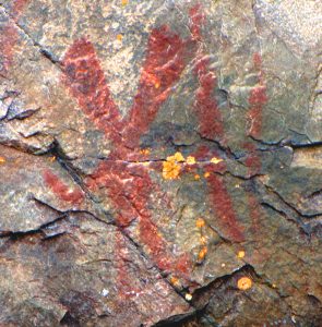
Red Ochre was also used for ‘Writing on Stone’ – more commonly referred to as ‘Rock Art’. Rock art is the oldest artistic tradition and has been practiced for at least 10,000 thousand years in North America. Rock art traditionally takes one of two forms, pictographs (paintings) or petroglyphs (carvings). This rock art was used to pass on lessons to future generations, as memory-markers representing wildlife, people, land, and regions, and acted as signage or wayfinding to convey instructions relevant to the territories (Rajnovich, 1994; Weeks, 2004). This art was commonly understood by many people and often conveyed knowledge about teachings, biodiversity, direction, and significant events to the peoples inhabiting regions (Rajnovich, 1994). Research suggests that rock art and oral traditions were pervasive amongst the first peoples of North America and, together, teach us about ancient totems, religious societies, ceremonies, medicine, animals, plants, astronomy, migrations, battles, as well as territorial boundaries (Rajnovich, 1994; Weeks, 2004).
Research on rock art is extensive and suggests that there are an estimated three to four thousand ‘writing on stone’ sites in Canada alone. Some of the more prominent sites include the Peterborough Petroglyphs; the Agawa Rock Paintings on Lake Superior; Bannock Point Petroforms in Manitoba; and Áísínai’pi Provincial Park (Aisinai’pi in Niitisitapi means Writing-On-Stone) located roughly 100 kilometres southeast of Lethbridge, Alberta, Canada.
Chert
Chert, also known as flint, is a hard, fine-grained rock that occurs as lumps on hard masses or as layered deposits formed in sedimentary environments. While chert is relatively common, high-quality cherts were a sought-after resource and only occurred naturally in relatively few areas. Archeologists today are able to determine the source of these materials through a visual inspection or trace elements analysis and draw inferences about the extent and nature of trade throughout the ages (Luedtke, 1978; 1979).
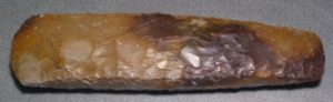
Chert artifacts have been recovered across North America and, in some cases, hundreds or thousands of kilometers from where they originated (Huynh & Steudber, 2012). The vast distances that these ancient artifacts travelled are evidence of the trade of exotic raw materials and provide a glimpse into procurement and distribution patterns in prehistoric populations (Baugh & Ericson, 1994b). These artifacts provide some of our earliest evidence of the existence of trade and distribution networks in North America dating back to 10,000 BC (Johnson, 1994; King, 2022). It is believed that exotic chert was procured and exported in broad-based exchange systems that involved highly skilled negotiators and specialized craftspeople (Lafferty, 1994).
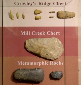
The value of chert derives largely from its utilitarian applications (Huynh & Steudber, 2012). Chert was most often crafted into cutting instruments, weapons, and agricultural equipment to provide the basic needs of a community. It was shaped and sharpened through a process called knapping or by grinding with another stone before being smoothed with sand and silt. Once crafted, the material could be attached to handles with sinew (sometimes infused with a binding agent) and function as tools (Huynh & Steudber, 2012). These tools were used for digging, chopping, cutting, shaving, drilling, engraving, carving, shaping, and smoothing. Artifacts crafted from exotic chert are often practical instruments such as axes, adzes, grinding tools, hammerstones, and large hoe blades which were used to manufacture other goods such as clothing, boats, shelter, and decorative art (Huynh & Steudber, 2012).
References
Ancient Americas (2021, May 11). Old Copper Culture: North America’s Forgotten Metal Workers. [Video]. https://www.youtube.com/watch?v=cpmMY_Rcbd8
Anselmi, L. M. (2004). A brief historical retrospective of investigations of Archaic to contact period copper-based metal artifacts in northeastern North America. Ontario Archaeology, 77(78), 81-94.
Barret, T. M. & Jarvis, D. J. (2019). The Historical Use of Ochre Pigments in Newfoundland and Labrador. Heritage NL Fieldnotes Series, Pp. 1 – 18. Retrieved from https://www.mun.ca/ich/resources/003_Use_of_Ochre_Pigment_NL.pdf
Baugh, T. G. & Ericson, J. E. (1994a). Systematics of the Study of Prehistoric Regional Exchange in North America. In T. G. Baugh & J. E. Ericson (eds.) Prehistoric exchange systems in North America. New York: Plenum Press.
Baugh, T. M. & Ericson, J. E. (1994b). Eastern North America. In T. G. Baugh & J. E. Ericson (eds.). Prehistoric exchange systems in North America. New York: Plenum Press.
Bourke, B. J. (1994). Evidence for Prehistoric Exchange on the Maritime Peninsula. In T. G. Baugh & J. E. Ericson (eds.) Prehistoric exchange systems in North America. New York: Plenum Press.
Brose, D. S. (1994). Trade and Exchange in the Midwestern United States. In T. G. Baugh & J. E. Ericson (eds.) Prehistoric exchange systems in North America. New York: Plenum Press.
Canadian Canoe Museum. (2015). Trade Patterns Before 1500. Peterborough, Ontario.
Carlson, R. L. (1994). Trade and Exchange in Prehistoric British Columbia. In T.G. Baugh & J.E. Ericson (eds.). Prehistoric exchange systems in North America. New York: Plenum Press. https://doi.org/10.1007/978-1-4757-6231-0_11
Clark, A. E, Dettman, D. L., Dungan, K. A., Grimstead, D. N., Pailes, M. C. & Tagüeña, N. M. (2013). Identifying the Origin of Southwestern Shell: A Geochemical Application to Mogollon Rim Archaeomolluscs. American Antiquity, Vol. 78, No. 4.
Connolly, T. J., Skinner, C. E., & Baxter, P. W. (2015). Ancient Trade Routes for Obsidian Cliffs and Newberry Volcano Toolsone in the Pacific Northwest. Toolstone Geography in the Pacific Northwest, 180–192.
Cooper, H. K., & Simonetti, A. (2021). Lead isotope analysis of geological native copper: Implications for archaeological provenance research in the north american arctic and subarctic. Minerals (Basel), 11(7), 667. https://doi.org/10.3390/min11070667
Descantes, C. & Erlandson, J.M. & Robertson, J.D. (1999). Geochemical Analysis of Eight Red Ochres from Western North America. Society for American Archaeology. American Antiquity, Vol. 64, No. 3 (July 1999). Pp. 517-526. Retrieved from file:///Users/jeremiecaribou/Downloads/Erlandsonetal.1999RedOchres.pdf
Dressay, A. L., Lavallee, N., & Reeves, J. (2010). First Nations Trade Specialization and Market Institutions. Aboriginal Policy Research Consortium International, 109–125.
Eells, M. (1894). Hymns in the chinook jargon language. https://doi.org/10.5479/sil.268843.39088005812680
Feinman, G. M., Nicholas, L. M., Robles García, N. M., Golitko, M., Elson, C., Faulseit, R. K., González Licón, E., Olguín, I., Pacheco Arias, L. D., Rodríguez, V. P., Ramón, G., & Allier, J. R. (2018). Prehispanic Obsidian Exchange in the Valley of Oaxaca, Mexico. Mexicon, 16–32.
Fowler, W. S. (1973). Metal Cutouts of the Northeast. Bulletin of the Massachusetts Archaeological Society, Vol. 34, No. 3 & 4
Galm J. R. (1994). Prehistoric Trade and Exchange in the Interior Plateau of Northwestern North America. In T. G. Baugh & J. E. Ericson (eds.). Prehistoric exchange systems in North America. New York: Plenum Press.
Gilbert, G. (1931). Copper on the Coppermine River, Northwest Territories. Economic Geology, 26 (1): 96–108. doi: https://doi.org/10.2113/gsecongeo.26.1.96
Hamilton, R. (2018). Indigenous Legal Traditions and Histories of International Law in the Pre-Confederation Maritime. Reflections on Canada’s Past, Present and Future. Centre for International Governance Innovation, 67 Erb Street West. Waterloo, ON Canada N2L 6C2
Hirch, M. (2003). Trading Across Time and Space: Culture along the North American “Grease Trails” from a European Perspective. Canadian Studies International Interdisciplinary Conference, 1–11.
History Museum. (N.D.). Coppermine River. Retrieved from: https://www.historymuseum.ca/cmc/exhibitions/hist/cae/par134ae.html
Huynh, D. & Steudber, K. (2012). A Guide to Saskatchewan Archaeology. Saskatchewan Archaeology Society.
Jobin, S. (2013). Cree Peoplehood, International Trade, and Diplomacy. Revue générale de droit, 43(2), 599–636. Retrieved from: https://doi.org/10.7202/1023207ar
King, H. M. (2022). Chert: What Is Chert? How Does It Form? What Is It Used For? Geology News and Information. Retrieved from: https://geology.com/rocks/chert.shtml
Lafferty, R. F. (1994). Prehistoric Exchange in the Lower Mississippi Valley. In T. G. Baugh & J. E. Ericson (eds.). Prehistoric exchange systems in North America. New York: Plenum Press.
Luedtke, B. E. (1978). Chert Sources and Trace-Element Analysis. Cambridge University Press. American Antiquity, Vol. 43, No. 3, pp. 413-423. https://www.jstor.org/stable/279398?seq=1#metadata_info_tab_contents
Luedtke, B. E. (1979). The identification of sources of chert artifacts. American Antiquity, 44(4), 744-757. https://doi.org/10.2307/279116
Lytwyn, V. P. (1997). A Dish with One Spoon: The Shared Hunting Grounds Agreement in the Great Lakes and St. Lawrence Valley Region. Archives of the Algonquian Conference, Carlton University. Retrieved from: https://ojs.library.carleton.ca/index.php/ALGQP/article/view/507
Moody, M. F. (2008). Eulachon Past and Present. The University of British Columbia, 1–59.
Morito, B. (2012). An Ethic of Mutual Respect: The Covenant Chain and Aboriginal-Crown Relations. University of British Columbia Press.
Quimby, G. I. & Ritzenthaler, R E. (1962). The Red Ocher Culture of the Upper Great Lakes and Adjacent Areas. Chicago Natural History Museum. Fieldiana Anthropology. Vol. 36, No. 11. Pp. 243 – 272. Retrieved from: https://www.jstor.org/stable/29782303?seq=1#metadata_info_tab_contents
Rajnovich, G. (1994). Reading Rock Art: Interpreting the Indian Rock Paintings of the Canadian Shield. Toronto: Natural Heritage Books.
Rickard, T. A. (1934). The Use of Native Copper by the Indigenes of North America. The Journal of the Royal Anthropological Institute of Great Britain and Ireland, 64: 265-89. doi:10.2307/2843810.
Sanger, M., Padgett, B., Larsen, C., Hill, M., Lattanzi, G., Colaninno, C., Culleton, B. J., Kennett, D. J., Napolitano, M. F., Lacombe, S., Speakman, R. J. & Thomas, D. (2019). Great Lakes Copper and Shared Mortuary Practices on the Atlantic Coast: Implications for Long-Distance Exchange during the Late Archaic. American Antiquity, 84(4), 591-609. doi:10.1017/aaq.2019.59
Scheiber, L. L. & Finley, J. B. (2011). Obsidian source use in the Greater Yellowstone area, Wyoming Basin, and central Rocky Mountains. American Antiquity, 76(2), 372–394. https://doi.org/10.7183/0002-7316.76.2.372
Sievert, A. K., Rogers, J. D., Urcid, J., & Smithsonian Institution. (2011). Artifacts from the craig mound at spiro, oklahoma. Smithsonian Institution Scholarly Press.
Stewart, R. M. (1994). Late Archaic through Late Woodland Exchange in the Middle Atlantic Region. In T. G. Baugh & J. E. Ericson (eds.). Prehistoric exchange systems in North America. New York: Plenum Press.
Veakis, E. (1979). Archaeometric Study of Native Copper in Prehistoric North America. [Doctoral dissertation, State University of New York at Stony Brook]. ProQuest Dissertations Publishing.
Vehik, S. C. & Baugh, T. G. (1994). Prehistoric Plains Trade. In T. G. Baugh & J. E. Ericson (eds.) Prehistoric exchange systems in North America. New York: Plenum Press.
Weeks, R. (2004). Oral Traditions and Native North American Literacy: Rock Art, Writing, and the Cadmus Myth. NEARA Journal, Vol. 38 No.2. Retrieved from https://neara.org/pdf/RexWeeks.pdf
Wright, J. V. (1994). The Prehistoric Transportation of Goods in the St. Lawrence River Basin. In T. G. Baugh & J. E. Ericson (eds.) Prehistoric exchange systems in North America. New York: Plenum Press.

.jpg)
Feedback/Errata